Why This Matters
Why This Matters
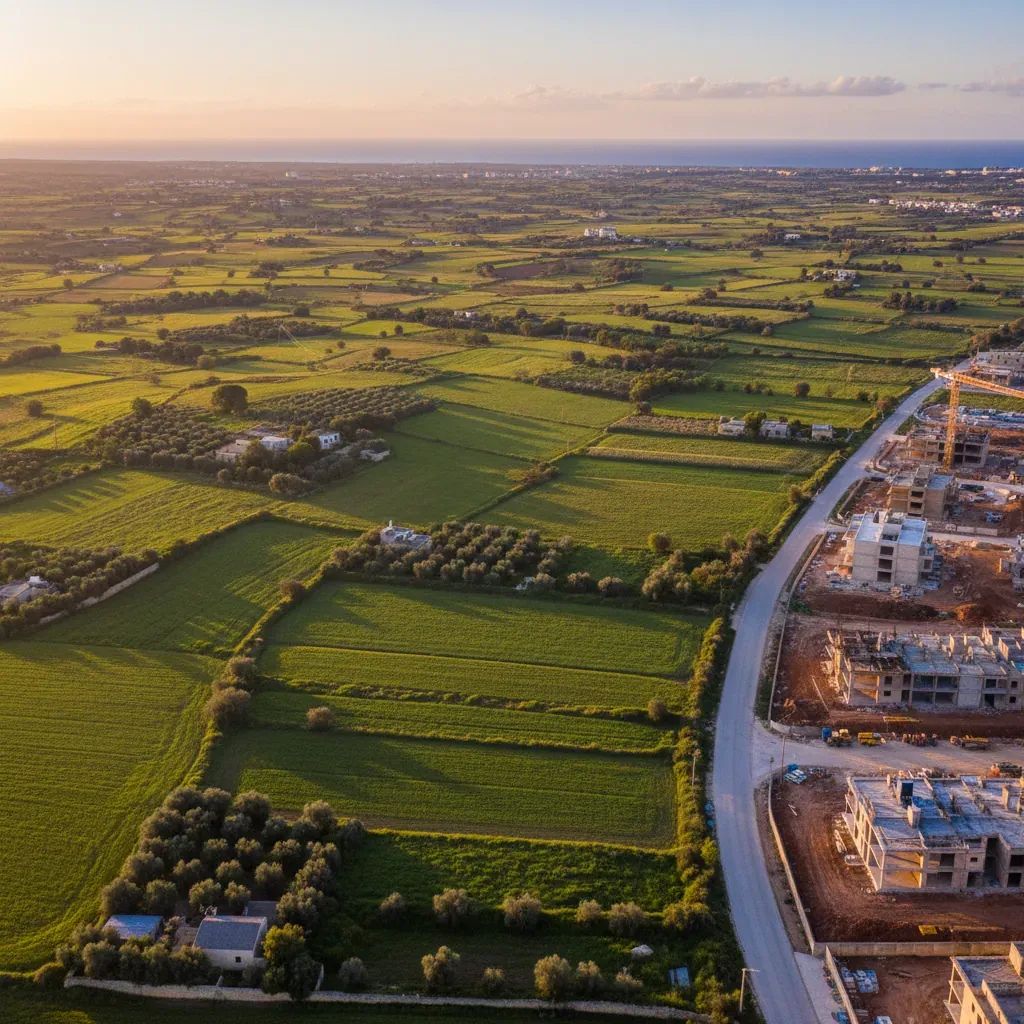
• Construction timeline: Residential buildings up to three storeys will replace agricultural fields within months after individual permits are filed—expect phased development over five to seven years.
• Parking crunch: The approval adds hundreds of new residents with minimal new parking provision, intensifying street-level competition in an already congested area.
• Staged archaeology: Heritage assessments will happen after zoning locks in building footprints—a reversal of standard practice that could limit future design flexibility if archaeology finds unexpected features.
• Commercial footprint: An 825-square-meter retail and office zone will introduce daily foot traffic and commercial hours into residential countryside.
A Decade-Long Fight Ends in Approval
On Tuesday this week, the Malta Planning Authority board greenlit a 41,000-square-meter residential and mixed-use scheme in Tad-Dib, Mosta, overturning an earlier rejection and finalizing a parcel of land that has been trapped between environmental protection and development pressure for nearly two decades. Developer Charles Azzopardi, working alongside 21 co-owners including the AX Group-owned Skyline Developments Limited, had first submitted the zoning application (PC/00021/19) in 2019. The board's approval, however, represents a reversal from the Malta Planning Authority's executive council, which had rejected a nearly identical scheme for the same location in March 2017.
The decision does not immediately trigger construction. Instead, it establishes the legal parameters—allowable building heights, road layouts, and density—that will govern future individual building permits. The 41,000-square-meter site sits adjacent to the historic Torri Cumbo and near the Mosta cemetery. It has remained largely untouched since Parliament controversially expanded the development boundary in 2006, a decision that opened roughly 2 million square meters of previously protected countryside across Malta to construction speculation.
Around 400 residents filed objections to Tuesday's decision, citing environmental harm, infrastructure strain, and the loss of working agricultural land. Despite these concerns, the Malta Planning Authority board acknowledged that once Parliament designates land within a development zone, reversing that classification becomes extremely difficult. The chair ruling the Tuesday hearing noted that while neighbors clearly preferred the land to remain open countryside, the legal foundation for development had already been established by government policy.
How the Plan Changed to Win Approval
The earlier 2017 rejection was scathing. The Malta Planning Authority's executive council had cited deficiencies in urban design, street proportions, residential density, and—critically—insufficient public green space. The original scheme failed to offset the visual and environmental impact of building on former agricultural land.
This time around, Falzon & Cutajar, the architectural practice representing the applicants, submitted a refined proposal. The revised scheme added 350 square meters of additional landscaped open space, introduced private front gardens for ground-floor residences, and carved a new internal road to break up what would otherwise appear as a monolithic block structure. Public open space now exceeds 1,392 square meters, scattered across the site. The plan also mandates that 70% of all designated green areas be fully planted with trees and shrubs rather than left as bare dirt or paving.
These concessions were sufficient to persuade the Malta Planning Authority board to overturn its own council's rejection. The board chair emphasized that the applicants had addressed the prior concerns meaningfully, and that the formal legal pathway—Parliamentary zoning—justified approval even if surrounding residents disagreed philosophically with development on farmland.
Archaeology and Heritage: Assessment After the Fact
The Superintendence of Cultural Heritage (SCH) had requested a comprehensive archaeological survey of the entire 40,000-square-meter site before any zoning approval, warning that buried structures, artifacts, or historical features could force design modifications or road relocations mid-project.
The developer's architects pushed back, arguing that assessing the full tract simultaneously was impractical and would delay the scheme unnecessarily. They proposed instead a plot-by-plot archaeological strategy, beginning only after the zoning framework was locked in.
The Malta Planning Authority board sided with the developer. The chair ruled that phased archaeology—block-by-block evaluation as each parcel moves toward detailed design—was feasible and would not compromise heritage protection. This decision reverses the conventional sequence: typically, archaeology informs zoning parameters, not the reverse. However, the board noted that the site's 40,000-square-meter scale made simultaneous assessment unwieldy.
An older structure on the site, initially flagged as requiring heritage protection (a "reserved matter"), will either be relocated or demolished, contingent on agreement with the Superintendence. The chair had worried that preserving it in place would create traffic complications; removing or moving it solves that logistical problem but introduces uncertainty about whether the Superintendence will accept relocation as preferable to demolition.
The Wildlife Question: Protection Through Conditions
Representatives from Nature Trust and affected residents painted a picture of the site as functionally rich. Tanya Chaytor, a neighboring property owner, testified that hedgehogs are regularly spotted crossing the fields, particularly at dusk. A Nature Trust representative described the land as home to various animal species, mature trees, and plant communities typical of rural Mosta. The organization has long argued that Malta's remaining agricultural parcels within or near development zones serve as ecological corridors and breeding grounds, especially critical as urban sprawl closes gaps between towns.
The Environment and Resources Authority (ERA) has mandated a natural habitat assessment before any full building applications proceed. This condition mirrors the archaeological requirement: evaluation happens after zoning approval, leaving developers and planners committed to a site layout that may need adjustment if the habitat survey reveals rare species or protected ecosystems requiring buffers or exclusion zones.
No explicit clause in the zoning approval requires active animal relocation or habitat restoration. The landscaping mandate—70% green coverage on designated areas—will introduce planted trees and shrubs, potentially attractive to displaced wildlife, but this is secondary mitigation rather than comprehensive habitat compensation.
The Parking and Traffic Trap
Residents raised immediate, concrete concerns about on-street parking and traffic congestion. Stephen Gatt, living adjacent to the development area, expressed particular anxiety about the loss of already-limited street parking spaces, warning that construction would eliminate what little availability residents currently enjoy.
The Malta Planning Authority board responded by imposing a vehicular access ban from Cumbo Street, a historic thoroughfare near the Torri Cumbo and Mosta cemetery. Pedestrian access from Cumbo Street remains permitted, protecting walkability while preventing delivery trucks and private vehicles from using the narrow, historically significant lane as a cut-through. Transport Malta, Malta's transport authority, did not formally object to the zoning proposal but attached standardized infrastructure conditions for future stages, signaling that when individual building permits are submitted, comprehensive traffic impact assessments will become mandatory.
However, the board did not mandate new public parking within the development zone or in surrounding streets. The responsibility for parking provision falls entirely on individual building applicants, typically met through private, resident-only underground or podium-level parking. This creates a practical gap: construction workers, commercial visitors, and overflow residents' guests will compete for street parking during the years that the site is under development.
The 2006 Rationalisation: Twenty Years of Controversy
The Tad-Dib approval sits within a larger political and environmental history stretching back two decades. In 2006, Parliament voted to reclassify approximately 2 million square meters of Outside Development Zone (ODZ) land across Malta into developable territory. The exercise, framed as correcting past zoning anomalies, effectively handed developers access to vast tracts of countryside that had been legally off-limits since the 1980s.
ADPD—The Green Party was represented at Tuesday's hearing by Carmel Cacopardo, who traced the Tad-Dib application directly to that 2006 decision. The party has consistently opposed the rationalisation scheme, arguing that it amounted to an environmental crime rooted in political patronage rather than genuine planning reform. Environmental NGOs point out that the exercise closed ecological corridors between towns, increased flood risk by replacing permeable soil with concrete and asphalt, and systematized development in ways that prioritize speculative profit over livability.
In Mosta alone, the rationalisation unlocked over 76,000 square meters of agricultural land, including the Tad-Dib and Ta' Mellu areas. Comparable reclassifications affected Attard, Rabat, Naxxar, and other municipalities. The Environment and Resources Authority has objected to specific road alignments that would extend beyond the original 2006 boundaries, calling such expansions "unacceptable" additional land consumption. Yet Parliament has never formally reversed the rationalisation, and no major political party has committed to doing so despite environmental pressure.
What Residents Can Expect
Mosta residents living near the Tad-Dib site should anticipate the following developments over the next five to seven years:
Construction and Access: Archaeological and habitat assessments will roll out sequentially, beginning with the first phase of the site. This phased approach means dust, noise, vehicle traffic, and temporary road closures will unfold in stages rather than all at once. Residents monitoring for individual building permits should track notices posted at the Malta Planning Authority or sign up for email notifications.
Commercial Activity: The approved 825-square-meter mixed-use zone will accommodate ground-floor retail, cafés, or office space with residential units above. This introduces daily pedestrian and vehicular traffic from external users—not just residents—altering the current rural character around the Torri Cumbo.
Parking Pressure: With minimal new public parking mandated in the zoning approval, competing for street-level spaces will intensify as the resident population grows. Residents without private parking will face longer search times, particularly in evenings and weekends.
Green Space Reality: The 70% landscaping requirement applies only to land officially designated as green space within the zoning framework. The majority of the site will remain built upon or paved for roads and utilities. The landscaped areas will be maintained by the developer initially, but long-term stewardship will likely transfer to a resident association or the Mosta local council.
What Comes Next
The approval does not trigger immediate construction. Developers must now submit individual building permit applications for specific plots, each triggering fresh archaeological and traffic assessments, environmental reviews, and public comment periods. Each permit application represents an opportunity for residents to raise new objections, though the zoning framework—heights, road layouts, building density—is now legally locked unless successfully appealed through the courts.
Developers typically move quickly once zoning is secured. Expect preliminary site preparation—surveying, temporary fencing, and archaeological trenching—to commence within months. The Malta Planning Authority has not disclosed a formal construction timeline, but the phased approval structure suggests the first residential blocks could be occupied within three to four years, with full buildout extending to seven years or longer.
Similar rationalisation-era sites in Attard, Rabat, and Naxxar face comparable trajectories: rezoned two decades ago, contested by residents and environmentalists, then incrementally approved as developers refine schemes to meet minimum thresholds. The Tad-Dib approval sets a procedural template for resolving dozens of remaining contested parcels, signaling that procedural concessions—additional trees, phased archaeology, traffic mitigation—matter more to the Malta Planning Authority than philosophical objections to farmland conversion itself.